Have you heard about georeferencing but aren’t quite sure what it means? It’s an operation that allows you to associate information, such as a photo or a 3D survey, with a real-world location on Earth. It’s used to know exactly where data was collected and to use it in fields like topography, construction, or GIS systems. In this article, we show you what georeferencing is, what it’s used for, and how to do it easily, even if you’re not a technician, thanks to tools like the high-precision GPS ProTRACK, compatible with the Matterport Laser Scanner.
Georeferencing refers to the process of assigning an object or information (such as an image, a point cloud, or a 3D model) a precise location on the Earth’s surface, using geographic coordinates (latitude and longitude) or cartographic coordinates.
For example, if you take a photo of a building and that photo contains GPS coordinates, you can say exactly where it was taken. This also applies to technical surveys, maps, 3D scans, or topographic data.
Without georeferencing, data exists, but it’s not localized.
What it’s used for in practice
Georeferencing technical data is useful in many professional fields. Here are some practical examples:
- In topography, to link surveyed points to a real-world reference system.
- In construction, to compare the project with the actual state of a building.
- In laser scanner or 3D camera surveys, to create georeferenced models (Digital Twins).
- In GIS and cartography, to position information on digital maps.
- In BIM, to coordinate design models and territorial data.
Additionally, georeferencing gives legal and technical value to data: a survey with real coordinates is verifiable, repeatable, and usable in official projects.
How to perform a technical georeferencing
Georeferencing can be carried out in two ways:
- Directly in the field, using a high-precision GPS/GNSS receiver, such as ProTRACK. In this case, the data is collected already georeferenced.
- In post-processing, using GIS or CAD software, by manually inserting known references (coordinates, control points, etc.).
For accurate georeferencing, a receiver that supports RTK corrections or a Base + Rover configuration is needed.
In complex surveys, such as those with drones or 3D cameras, this process is essential to obtain data consistent with reality.
Practical example: georeferencing a 3D scan
Let’s take a real case.
You performed a 3D scan of a building using a Laser Scanner like Matterport Pro3. The result is a detailed, navigable 3D model, useful for representing spaces. But there’s one problem — it doesn’t have real coordinates.
To make that digital twin usable in GIS, CAD, or BIM, you must georeference it.
How? By collecting accurate GPS points corresponding to visible references in the scan.
This way, you’ll be able to export your survey in a georeferenced E57 format, compatible with all technical software.
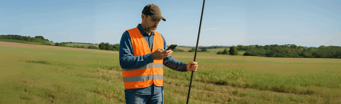
ProTRACK: a helpful tool if you want to do it easily
If you want to simplify the whole process, you can use
ProTRACK, a GNSS receiver developed by Analist Group, designed specifically for precise surveys, even on the move.
With ProTRACK you can:
- Collect GPS points with centimeter-level precision, even in areas without network thanks to the Base + Rover mode.
- Associate the points to your 3D survey, obtaining a digital twin perfectly aligned with reality.
- Work in the field directly with your smartphone and an intuitive app.
- Export the data in a compatible format (e.g., E57) for processing in CAD, GIS, BIM, or technical management.
This allows you to automate and speed up the georeferencing process even if you’re not an expert.
Georeferencing is an invisible yet essential operation. It’s what turns a simple image or 3D model into useful, located, and valid data for designing, building, measuring, and documenting.
If you want to start working with precise georeferenced data and simplify your workflows, you can explore the use of tools like ProTRACK from Analist Group. It allows you to obtain georeferenced surveys in real time or offline, with maximum ease.