Precision farming has become the most important technique for those who want to cultivate efficiently and sustainably. In this article, I’ll explain how centimetric GPS surveying works in agriculture and why it’s essential to use professional tools like ProTRACK. You’ll discover the benefits of this technology, how to improve productivity by reducing waste and costs, and how to choose the right receiver for your work.
In recent years, there has been more and more talk about precision farming. But what exactly is it? It’s a new way of farming that uses technology to optimize every operation in the field. And when we say every operation, we really mean every meter. In fact, every centimeter.
What is precision farming and why does every centimeter matter
Precision farming is a set of innovative techniques that allow farmers to monitor and manage crops in a targeted way, using data, maps, and GPS. Unlike traditional farming, which treats the field as a uniform area, precision agriculture considers each part of the land as a distinct entity, with specific characteristics and needs.
This means that every area of the field can be monitored and managed individually: from sowing to fertilizing, from irrigation to harvesting. That’s why terms like soil mapping and prescription maps are often used: tools that allow resources to be distributed only where needed, in the right amount.
Thanks to sensors, prescription maps and precise coordinates, it is possible to know exactly where to intervene, when to do it and with what quantities of product. But why does “every centimeter count”? Because even a small positioning error can lead to waste of seeds, fertilizers, or chemical treatments, negatively impacting both costs and the environment. Thanks to modern agricultural GNSS systems and RTK technology, it is now possible to work with centimetric accuracy that guarantees maximum yield with minimal effort.
Why GPS is used in agricultural fields
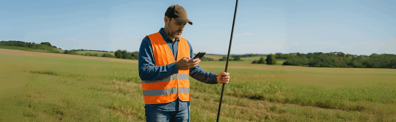
You’ve probably seen high-tech tractors or drones flying over fields. Behind these technologies there’s a common element: agricultural GPS. But not just any GPS. When sowing or applying treatments (fertilizers, pesticides, etc.), it’s essential to have reliable coordinates. Only this way can you create detailed prescription maps and perform localized and precise interventions.
In this context, devices like ProTRACK, an advanced GNSS receiver, prove to be fundamental. Used for precision farming, ProTRACK allows you to acquire georeferenced data with extreme precision, facilitating soil mapping and targeted interventions.
RTK and GNSS in agriculture: why standard GPS is not enough
The GPS in your smartphone has an accuracy of a few meters. But in agricultural surveys this margin of error is not acceptable. That’s why advanced technologies like RTK (Real Time Kinematic) and GNSS are used, enabling centimeter-level accuracy.
Devices like ProTRACK use these technologies to provide real-time positioning data, even without internet connection, using the Base-Rover mode.
Benefits of centimetric GPS surveying in agriculture
Using a centimetric GPS for agriculture brings concrete benefits:
- Waste reduction: precise dosing of seeds, fertilizers and chemical treatments.
- Greater operational efficiency: precise surveys and detailed maps facilitate targeted agronomic decisions.
- Increased productivity: timely and localized interventions improve crop yield.
- Environmental sustainability: targeted interventions reduce the use of chemicals.
- Full traceability: every activity can be georeferenced, facilitating compliance with regulations.
With ProTRACK, these benefits are amplified: it allows soil mapping, locating problematic areas, and intervening in a targeted manner, even with the help of multispectral drones for agriculture that work in synergy with the data provided by the receiver.
Why choose a receiver like ProTRACK
ProTRACK is an RTK receiver for agriculture designed for the agricultural world, equipped with all the necessary features to handle even the most difficult conditions:
- Centimetric accuracy: ±1 cm + 1 ppm.
- Update rate: 10 Hz, ideal for dynamic surveys.
- High-performance antenna: optimal reception even in complex environments.
- Base + Rover mode: for working even without a mobile network.
- Compatible with RTK drones: useful for generating vegetation maps and localized treatments.
ProTRACK is the ideal choice for those looking for a GPS for precision sowing, variable rate treatments or crop monitoring with reliable tools.
Software and data management
Simplicity doesn’t stop at hardware. ProTRACK can be integrated with Analist Mobile, which allows GPS agricultural surveys even offline. The collected data can then be processed in Analist CLOUD, the precision agriculture software powered by Autodesk Technology.
Thanks to this software integration, it is possible to digitize and optimize field management, improving productivity and reducing costs.
Is it easy to use?
Absolutely yes. Analist Mobile is designed to be intuitive even for beginners. Moreover, ProTRACK has an 18-hour battery life, is resistant to dust, humidity and extreme temperatures. You can start working with one click, even without a mobile network, and get accurate data right away.
This makes ProTRACK the perfect tool for those looking for an agricultural GPS that is easy to use yet delivers professional performance.
Until a few years ago, precision agriculture seemed like something only for big companies or experimental labs. Today, it’s within everyone’s reach. Thanks to solutions like ProTRACK, even small farmers can leverage professional RTK technologies, increase yield and reduce costs.