Do you need to perform a parcel division or a boundary retracement? Don’t worry: today, thanks to modern professional GPS devices, you can obtain accurate and reliable cadastral surveys in just a few steps, even without an internet connection. In this guide, we’ll walk you step-by-step through what a GPS cadastral survey is, how RTK technology works, when centimeter-level accuracy is needed, and how to get started immediately with ProTRACK, the ideal GPS for surveyors and technicians. You’ll also find answers to the most common questions about legality, timing, and necessary tools.
If you’re about to carry out a parcel division, need to draft a cadastral map, or are involved in a boundary retracement, you probably already know how important precision is.
But don’t worry: today, technology comes to the rescue, and with modern GPS tools for cadastral surveying, it’s possible to work simply, quickly, and reliably. In this article, we’ll explain everything you need to know to get started right away.
What is a GPS cadastral survey
If you need to define the exact boundaries of a plot, update cadastral maps, or settle a dispute with a neighbor, a GPS cadastral survey is the simplest and most effective solution. This type of survey helps identify the actual location of points on the ground and relate them to the official maps from the Cadastre.
In other words, it allows you to know exactly where your property ends and where your neighbor’s begins. If you’re wondering how to do a GPS cadastral survey, don’t worry: it’s easier than you think — we’ll explain it all step-by-step.
How GPS works in the cadastral field
To perform reliable cadastral surveys, you need centimeter-level precision: even one or two centimeters can make a big difference.
For this reason, professionals use professional GPS devices called GNSS, which operate using an advanced technology called RTK: a fixed Base sends real-time corrections to a mobile Rover that performs the survey. Thanks to this data exchange, errors are reduced to just a few centimeters or even less. This is commonly known as the Base + Rover system.
The system also works with permanent GNSS networks that provide corrections via the internet — but as we’ll see, you can also perform cadastral surveys without a network if you have the right tool.
When centimeter-level accuracy is truly needed
Not all surveys are the same. Sometimes a simple map is enough, but in other cases maximum precision is required. Here’s the difference:
- Map-based survey: relies only on the graphical representation of parcels. It’s not very accurate and often insufficient for official purposes.
- Exact coordinate survey: requires precise instruments and a correct geodetic reference. Here, an RTK GPS is essential.
- On-site survey (boundary retracement): the most delicate case, involving historic boundaries or disputes. You must use a precise and reliable GPS, or you risk legal problems.
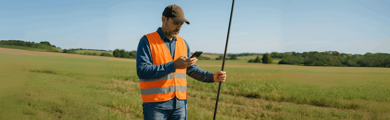
Getting started with ProTRACK
If you’re looking for a tool that’s easy to use, ready-to-go but also professional, we recommend starting with ProTRACK.
This professional GPS offers:
- Centimeter-level accuracy even in areas without internet coverage, thanks to Base + Rover mode
- Multi-constellation support (GPS, Galileo, GLONASS, BeiDou) for better reliability
- Battery life of up to 18 hours, so you can work all day without interruptions
- Analist Mobile app for managing projects, uploading cadastral maps in real-time, and simplifying the workflow
- Resistance to extreme environmental conditions, operating at temperatures between -40°C and +85°C
With the Analist Mobile app, you can:
- Manage your survey projects directly on-site, even from a tablet or smartphone
- Upload cadastral maps for a clear reference during work
- Save the measured points
Once the survey is complete, you can import the data into the Analist CLOUD software, powered by Autodesk technology, to:
- Automatically generate the cadastral report
- Verify fiducial points and boundaries
- Prepare export for Pregeo, already formatted to meet the Revenue Agency’s specifications
- Create elevation profiles, contour lines, and 3D terrain models
The entire process — from field survey to producing cadastral documentation — is designed to make your life easier.
With ProTRACK, you can carry out cadastral surveys without a network, working even in rural or remote areas. It’s ideal for surveyors, technicians, and professionals who want a reliable, portable tool without complex setups. In fact, no complex configurations, extra licenses, or advanced skills are required: just power on the device, start surveying, and you’re ready in minutes.
Frequently Asked Questions
Can I create a cadastral map with GPS?
Yes, you can. To draw up a cadastral map, you must use a high-precision GPS based on RTK technology. The Cadastre requires surveyed points to have a very low error margin, just a few centimeters. If your device allows it and you follow the correct procedures, you can easily use GPS to create a cadastral map. Today it’s one of the most widely adopted solutions.
Do I need an internet connection to perform a cadastral survey with GPS?
No, it’s not mandatory. If you use a GPS like ProTRACK, you can also work offline, thanks to Base + Rover mode. This means you can survey even in remote areas like rural zones or mountainous regions. If you do have a stable connection, you can use GNSS networks to receive real-time corrections. Either way, the result will be accurate.
Is it legal to use GPS for cadastral surveys?
Yes, it’s absolutely legal. The key is to use approved equipment, meaning a GPS that ensures centimeter-level accuracy. You also have to follow the technical guidelines provided by the Revenue Agency. If you meet these conditions, you can confidently use GPS for tasks like parcel divisions, cadastral maps, and boundary retracements.
How long does a GPS survey take?
It depends on the task, but in general, not long. With a simple system like ProTRACK, you only need a few minutes to turn it on, set it up, and get started.
For a small cadastral survey, you can often complete it — including data processing — in less than half a day. That’s one of the main reasons more and more professionals are switching to GPS-based cadastral surveys.
Today, performing a GPS cadastral survey is much easier than in the past.
With a tool like ProTRACK, you don’t need complex networks or internet connections: just turn on the device and start working. Whether you need to prepare a cadastral map, parcel a property, or define a boundary, all you need is a suitable GPS surveying tool — and you’re ready to go.