Carrying out precise surveys on site is not always easy. A misaligned excavation or an incorrect elevation can lead to problems, delays, and extra costs. Fortunately, today there’s a practical and effective solution: based on ProTRACK for GPS surveying in construction.
In this article, we’ll explain in simple terms how GPS on the job site works, what you can do with these tools, and why it makes sense to use them instead of traditional methods. We’ll also show you how to work better using ProTRACK, the professional GPS that also works without network, and how to combine it with Matterport to achieve a precise, digital, and complete 3D survey.
Why precise surveying is essential on site
If you work on construction sites, you know how important it is to be precise: even one excavation in the wrong spot or a misplaced foundation can cause problems, delays, and additional costs.
Fortunately, today there are professional tools that help you work faster and without mistakes. Among these are high-precision GNSS receivers, often used on construction sites, because they tell you exactly where you are and where you need to operate. This way, you avoid mistakes, save time, and work safely.
In this article, we’ll explain how GPS works on site, with a focus on ProTRACK, how to use it, and why it can be useful together with other digital tools like the Matterport laser scanner.
How GPS works in construction
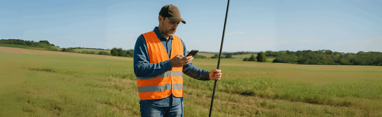
The GPS on your phone is convenient for finding an address, but it’s not accurate enough for job site work. That’s why more professional devices, called GNSS, are used: they can detect the exact position of a point on the ground.
With these tools you can:
- measure the terrain before starting work,
- check that elevations are correct,
- carry out the project step by step without risking errors.
What you can do with a GPS on site
Using GPS allows you to:
- Survey already-built foundations to check if everything matches the project;
- Mark excavation lines, walls, or specific points on the ground;
- Check the elevation (height) of a point to see if it needs to be raised or lowered.
In practice, with a professional GPS you can work better, faster, and without having to redo measurements multiple times.
Why it’s better than the classic method
Until a few years ago, this work was done using measuring tapes, optical levels, and lots of manual labor. Today with GPS:
- You save time;
- You avoid mistakes;
- You have everything saved digitally, ready to use on your computer;
- You can work even on your own, without needing other operators.
What is ProTRACK and why it’s useful
One of the easiest tools to use is called ProTRACK. It’s a GPS for construction that works even without Internet connection.
All you need to do is:
- Turn on ProTRACK;
- Connect it to your smartphone via Bluetooth;
- Open the app (available for Android and iOS);
- Start surveying points, elevations, and lines on the ground right away.
With ProTRACK you can:
- Load cadastral maps live to compare them with reality;
- Survey in the mountains or countryside, even with little or no network;
- Export the data into compatible files for your design software.
Moreover, it’s water- and shock-resistant: perfect for on-site use.
If you also want to see the site in 3D: ProTRACK + Matterport
Sometimes knowing where a point is located isn’t enough—you also need to see what it looks like. That’s why you can use ProTRACK along with Matterport, a Laser Scanner that captures reality and creates a 3D digital twin of the site.
With this combination you can:
- Measure with ProTRACK;
- Scan the environment with Matterport;
- Combine the two data sets for an accurate and realistic survey;
- View everything on your computer or with a 3D viewer.
It’s very useful for SAL (Work Progress Reports), for communicating with clients, or for archiving the exact site condition at a given date.
Data export is easy
You’ve collected the data with ProTRACK and Matterport and now you’re wondering how to process them? No problem: just use Analist CLOUD.
Analist CLOUD is software based on Autodesk technology that lets you easily import field data, view it clearly, and turn it into plans, 3D models, sections, and much more.
GPS surveying in construction is now an indispensable tool. It helps you be precise, fast, and avoid mistakes. With ProTRACK, you can do everything independently straight from your smartphone. And if you also want a visual representation of the site, you can pair it with Matterport to get the best results.
If you work in construction and want to improve your surveys, this is the simplest and most complete solution you can use today.